
Geographical Situation

Geographical Situation
There is a splendid outlook over the sprawling city and over five high solitary mountains from several spots, in the southwest to the southeast (Menagesha, Wachecha, Furi Zukuala and Yerer).
Facing north from the top ridge, one looks out over vast plains, towards Sululta and some bare mountains.
The mountain ridge on which the Park is located constitutes a big water divider. The northern slope drains into the Blue Nile, and the precipitation
from the southern slope will
End up in the Awash River.
This has the curious result that two raindrops falling at the same time just a few centimetres apart will have entirely different destinies: one will, after a long journey, reach the Mediterranean Sea, whereas the other will pass through the city of Addis Ababa, eventually evaporating in the Danakil Desert, as the Awash River never reaches the sea.
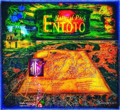
The lower part of the Park adjoins Addis Ababa's northern outskirts, at the district known as Shero Meda (Shiromeda).
Coming from the central parts of the city, the Entoto Avenue leads up to the school of Kuskuam in the north of Shero Meda and further along the border of the Park to the Church of Entoto Maryam (Håkan Blanck and Pia Englund, Entoto Natural Park 1995).
Shero Meda (Shiromeda) - Central Station for Bus and Taxi.
This community in the capital's northern district offers a central station for further taxi and bus services to the Capital's city centre and a direct taxi connection to Entoto Maryam and Entoto Kidane Mehret.However, the town and station Shero Meda is close enough to Entoto Kidane Mehret to offer a pleasant walk to Entoto Natural Park. Shero Meda (Shiromeda) also allows the easiest access to Entoto Maryam, located on Entoto's plateau.
Entoto Kidane Mehret Church and Community.
Although this rock-based sanctuary and society towers within the Capital's northern boundaries and its mountain massifs, it seems to be very preserved and well above all stressful whims.Furthermore, this Church and Monastery are astonishing hidden, tucked into the mountain massif rising shoulder where perception arises very soon to be careful because precipices and gullies take over immediately when you just move away from a little piece of this remarkable protective town.
A Mountain-based Station for Bus and Taxi.
Although Entoto Kidane Mehret is quite highly located and appears distant due to its height above the Capital, it's equipped with a station for regular bus and taxi traffic.This quaint town's structure creates here a harmonic embrace of the extensive and impressive Entoto Kidane Mehret Church (32), Monastery and Sacred Water Source (31), Juniperus procera Forest (indigenous) 30. https://goo.gl/maps/58V2EvcmpVPcgeGx8
The choice of Entoto Kidane Mehret as a central base for further exploration of the Park is natural because both the Capital's buses and municipal taxis regularly have this place as the final location.
They are here waiting in the shade of large native trees before they again turn downhill and soon arrive in the Shero Meda (Shiromeda) station and society and further the more central part of the Capital.
Elevated Protectorate.
Entoto Kidane Mehret is a very dedicated and appealing mountain town but should more precisely be described as a profoundly religious Sanctuary and Protectorate of Nature and Inhabitants.For a long time, this has been a religious protectorate of Entoto's nature, thus gaining unique and profound protection that has been deeply associated with religious devotion and conviction.
However, the Hotel and Guesthouse is missing, which means that the nearest accommodation for tourism and dining is the Shero Meda (Shiromeda) community.

Comments
Post a Comment