
Direction Map to the Alluring Past
Direction Map to the Alluring Past
The Celestial Dreams' Forgotten Landscape

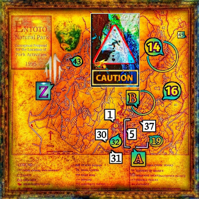
Bees' Cliff 14 requires Caution in the Canyon but assistswith the wide map loop surrounding the gentle andfascinating tributary 36 to the Canyon and 41-42.
The Path to the Gorgeous River-DellThe hidden path between the Sanctuary and the gorge runs attractively behind Entoto Kidane Mehret (32) in a concealed curve below its wall and passes through a small part of the village before the path (5) opens along a deep ravine and finishes with a downhill towards a traditional bridge. This bridge, which crosses the sculptural gorge within the valley [A], serves as the cosy picnic source (19) and also marks the natural starting point for more dramatic hikes towards the high plateau, accessible via the first passing point (37) or (19).
Shops for Picnics and AdventuresThe most necessary parts of the park's experience, such as picnics and candy shops, are across the bus or taxi stops from the communities (1), (43), and (Z). For those very early in the dawn, there is a small shop at the beginning of the Juniper forest, just next to the health spring with its associated buildings (31). Restaurants and amenities at Entoto Kidane Mehret (1), Entoto Maryam (43) and Entoto Park (Z):
 |
Bees' Cliff 14 requires Caution in the Canyon but assists with the wide map loop surrounding the gentle and fascinating tributary 36 to the Canyon and 41-42. |
The Path to the Gorgeous River-Dell
The hidden path between the Sanctuary and the gorge runs attractively behind Entoto Kidane Mehret (32) in a concealed curve below its wall and passes through a small part of the village before the path (5) opens along a deep ravine and finishes with a downhill towards a traditional bridge. This bridge, which crosses the sculptural gorge within the valley [A], serves as the cosy picnic source (19) and also marks the natural starting point for more dramatic hikes towards the high plateau, accessible via the first passing point (37) or (19).
Shops for Picnics and Adventures
The most necessary parts of the park's experience, such as picnics and candy shops, are across the bus or taxi stops from the communities (1), (43), and (Z). For those very early in the dawn, there is a small shop at the beginning of the Juniper forest, just next to the health spring with its associated buildings (31). Restaurants and amenities at Entoto Kidane Mehret (1), Entoto Maryam (43) and Entoto Park (Z):
The map sign of square [A] simplifies Entoto Kidane Mehret's valley, which is more dramatic and extended with its gorge and river dell. Thus, this map square [A] serves as a directed and facilitating figure to find points (5), (19) and (37) more efficiently, which are located and form the valley at Entoto Kidane Mehret (32). Within this valley [A] begins most of the following hiking trails, which extend up to the southern rim of the high plateau at points (14) - (16) and much farther.
B. The Invitation to the Crossroad of Wilderness
The serene, gently ascending hike from the valley [A] soon reaches the map loop (B), which encircles points (35), (38), and (39) and constitutes both a crossroads of somewhat wild paths and a beautiful rise on a ledge of some metres threshold. This crossroads is just to the right of the fort ruin (38) - (B), with exceptionally cosy views just at the Canyon's water flow. However, regardless of the hiking paths from the loop point (B), these will soon continue towards higher positions.
The Assistance To Direction and Orientation

Detailed Description of the Hiking Trails
Bees' Cliff 14 assists by the vast map
loop surrounding points 36 and 41-42
 |
| Detailed Description of the Hiking Trails Bees' Cliff 14 assists by the vast map loop surrounding points 36 and 41-42 |
The Intended Clockwork Of Loop (B)
While this type of orientation assistance is compatible with visitors of foreign habits, other requirements are demanded to fulfil the tradition of the native population, who prefer to use their own orientation in the landscape of the revered past.
Tools Of Orientation Within the Map Circle (B)
When considering the circle (B), the possibility arises of using it as a directional pointer of the type that uses the traditional dial of the pointer's intended tip as an excellent tool for finding otherwise hidden objects. Thus, the intended end set at 3:30 shows a pleasantly elevated area above the field (39) within the map loop (B). This metre-raised ledge is the site of several unique and older native Juniper procera trees. These furrowed Juniper trees tower, awe-inspiring, dominating the surroundings like a mighty crown on the slope above the field (39).
A Charming Highland Landscape
Among Gorgeous Meadows and Dramatic Waterways
When the circle (B) with its intended pointer reaches its full extent at 4:30, it points to an area just south of the field (39) - (B). This rather wild and wavy slope is a fantastic area with a certain number of native Podocarpus trees, all muscularly proudly posing in antique motion on this hilly southern slope. The high plateau's Abyss, deeply beneath Bees' Cliff (14), requires Caution in the Canyon but is assisted by the wide map loop (14) surrounding the gentle and fascinating points (36) and 41-42.
Nature and Trees from the Historical Era
 |
| Podocarpus falcatus (P. gracilior ) |
Some Podocarpus trees from a previous era appear admirably muscular, furrowed around the extensive farmhouse area (39) within the map circle (B). On the elevated ledge just above the farmhouse (39), large Juniperus procera trees tower on the upper hillside. Very soon after the map loop (B) towards a higher altitude, the path turns slightly to the right towards the location (16). Just at the high plateau's outer edge is a place with great, serene views (16) and many incredible stately Juniper trees.
The intended direction indicator within the map circle (B) enables a method that utilises a limited length in the intended dial. This method also allows distinguishing objects more centrally located on the intended clockwork. Consequently, as this intended pointer reaches 60% of its entire length, and at four o'clock, it becomes possible to find a magnificent native Podocarpus tree to the left of the hiking trail.
Seasons for Wonderful Picnicking and Hiking 
The High Plateau with Spring Water and Bath
Caution: Rainy Seasons and Climate
** Caution for Thunderstorms' DelugesAdventure History: "Entoto's climate during the rainy season was far from pleasant, for it suffered from many storms. A French traveller, Jules Borelli, states that it was a place of much lightning, thunder and fog, while his compatriot, Charles Michel, remarked that ''exposed to the wind, difficult to access, and without drinking water'' (Ibid, p.103).
Photographs Among Highland BrooksThese photos of water-filled streams and cascading waterfalls were taken just above Bees' Cliff (14) at Entoto's southern highland plateau from early October to mid-November. Therefore, it has been about one to two months since the long rainy season ended when these active water sports photographs were captured. Although any earlier date for baths allure, they must come with care for the water's torrential forces.
Seasons for Wonderful Picnicking and Hiking
 |
| The High Plateau with Spring Water and Bath Caution: Rainy Seasons and Climate |
Adventure History: "Entoto's climate during the rainy season was far from pleasant, for it suffered from many storms. A French traveller, Jules Borelli, states that it was a place of much lightning, thunder and fog, while his compatriot, Charles Michel, remarked that ''exposed to the wind, difficult to access, and without drinking water'' (Ibid, p.103).
Photographs Among Highland Brooks
Photographs Among Highland Brooks
These photos of water-filled streams and cascading waterfalls were taken just above Bees' Cliff (14) at Entoto's southern highland plateau from early October to mid-November. Therefore, it has been about one to two months since the long rainy season ended when these active water sports photographs were captured. Although any earlier date for baths allure, they must come with care for the water's torrential forces.
A Grandiose Viewpoint with Exciting Adventures
The Resting Place from the Era of Dreams
Arriving at the high viewpoint and the outermost plateau ledge (16), this seductively blooming fragrance adventure appears, despite the challenges, as entirely captivating. Although this mountain exploration offers a somewhat thrilling experience with a hint of demand, all this is because the substantial rise in the mountain's southern hillside provides several wonderful and exciting rests with magnificent sceneries. Therefore, this highland route offers an excursion with its typical mountain's tempting highland air and enchantingly harsh terrain.
 |
A little behind the camera's typical view of the dim-capped Capital is a group of magnificent and powerful Juniperus procera trees. These indigenous Juniper trees are unique and appear to have an origin from a past culture, and are here very near, just some steps uphill towards Bees' Cliff (14). This picture shows native Juniper trees from the plateau ledge No.16 view |
Entoto Maryam and Entoto Kidane Mehret
Historical Sanctuaries
 |
| Museum and Palace on the High Plateau | Google Maps: Palace Of Emperor Minilik and Empress Taitu 1883. |
On the Mountain's High table, this image presents the Palace of Emperor Minilik and Empress Taitu, 1883, at Entoto Maryam (43). This historic place on the mountain's high table is the site for the Former Capital, a historical Palace and a cosy town. With accessible trails, this high plateau offers surprisingly gentle terrain in reasonably close contact with great views over the landscape beneath, including the fashionable and cultural facilities with activities of Entoto Park (Z). Adorned with two welcoming towns, Entoto Natural Park appears surprisingly cosily quaint, yet with a flavour of drama thanks to the magnificent Nature. Hence, Entoto Maryam (43) offers an invitingly charming site for the whole family, with quaint access to restaurants, a museum, and a Palace within this town on the grand high plateau. Another lovely choice is Entoto Kidane Mehret (1), which has an extensive sanctuary, restaurants, and excellent natural areas for picnics. Therefore, these charming mountainous towns appear culturally welcoming and captivating with their beautiful, gentle surroundings. (Photo to the right by David Stanley)
_20190923130315923-01-01-01.jpg) |
| This Sanctuary (32) is astonishingly hidden, tucked into the mountain massif rising shoulder where perception arises very soon when moving away a bit of piece of this protective town Entoto Kidane Mehret (1) |
The Hidden Path of Entoto Kidane Mehret
Hidden behind Entoto Kidane Mehret (32), this path makes a concealed curve below the Sanctuary's walls. It passes through a small part of the village before the way (5) opens with a sculptural ravine and continues toward a traditional downhill bridge. The view unfolds in a scene of breathtaking beauty, featuring an irresistible, cosy river dell where the children play, and laundry dries on the inviting, soft, clean, polished rock bed. This place is an appealing beauty to appreciate on the first steps along the Sanctuary and the following bridge below Entoto Kidane Mehret (32). (Photo to the left by Ninara)
The Sanctuary's Gate to the Mountain
The Sanctuary's Gate to the Mountain
 |
| Bees' Cliff 14 requires Caution in the Canyon but is assisted by the wide map loop surrounding the gentle and fascinating points 36 and 41-42 Maps and Routes To the High Plateau |
A refreshing cool stream still runs in leaps and joy beyond the secrets of Entoto Kidane Mehret's sacred stone walls (32), a path to Bees' Cliff (14), and further exhilarated explorations. The trail runs attractively behind the Entoto Kidane Mehret's Sanctuary (32) in a concealed curve below its wall. The path passes through a small part of the village before opening along a deep ravine (path 5) and finishing downhill towards a traditional bridge, shown within the open map square [A].
Canyon Trails to the Highlands
The Assistance Of Paths' Directions
A Mountainous Picnic Site with Dramatic Views.
Exciting Exploration with Picnic and Waterfall
Grande Family Adventure with Views and Picnics
The Trail Options Above the Circle (B) appear with several very different path choices just uphill from point (38) - (B) but also become enriched by a more thorough, independent acquaintance with the full south-eastern to north-western eroded soil road (41) located just to the right of points (14 - 16). The paths up to Bees' Cliff (14) offer several options, including the northern hillside of the tributary gorge (36) within the loop (14), as well as the southern slope of (38-39) - (15-16) and (41).
An Inviting Guide to the Mountain
The superficial water-conducting metal pipe (37) - [A] assists the mountain hike where its apparent suitability begins on the slope above the valley [A]. This place is easily reached from below the valley [A] with a comfortable pass between a couple of cottages before it continues and reaches a gentle high level on the mountain's shoulder. Just before the Italian fortification (38) - (B), a theatrical view and potentially dangerous Abyss appear a few metres to the left of the path. This precipitous view is within the lower map loop (B) regions and includes route deviation in three choices. The pipeline makes its high northern bend just to the right of (38) - (B). At this upper and most northern point of the pipeline, the path diverges from the pipeline onto a threshold of the steeper uphill path, which provides the direction for most hiking routes.
Cliff-Hiding Ruins and Furrowed Trees from Lost Aeons
However, for visitors with an active outdoor life, this mountain's undulated hillside allures in pleasure for exploring historical surprises with old Italian fortifications (38) - (B) and trees of a surprisingly dignified furrowed patina within the map loop (B). For those who want a wild and mysterious experience, Juniper Forest is a nearly 50-year-old forest of wild and original Juniperus procera trees just east of point (16). This indigenous Juniperus procera forest (40) is close but still hidden behind a gentle ridge of this viewpoint (16) and on the eastern slope. This hidden forest (40) and the native Juniper trees in this picture provide a unique insight into how nature emerged before the Eucalyptus trees were introduced from Australia to Ethiopia over 100 years ago.
Hiking Towards Waterways and Enigmatic Ruins
 |
| Picnics & Baths |
After following upwards from point (37) - [A] to the highest bend of this guiding coarser water pipe, the site of magnificent views over the Valley [A] appears. This path is a short section, deviating some tens of metres from the path upwards to reach the ruin of the Italian fort (38) - (B) and its water facility. This place opens into an attractive clearing on a high cliff ledge, thereby characterizing the place's high-lying drama. However, the underground water fort is also fascinating and thus appeals to picnics with fantastic views and an entertaining exploration.
** Caution: It is clear that the site of (38) - (B) has a steep precipice towards the Valley [A] and thereby requires a cautious alert. Still, this offers extra pleasure in grand views, thus giving the picnics or the hike extraordinary value. Furthermore, this place (38) - (B) constitutes the initial gate to the Canyon's water flow, requiring Caution during the rainy season's dangerous torrential deluges.
This relatively high-lying, picnic-inspiring grass glade at (38) - (B), with its hidden rock fortress, evokes a sense of anticipation due to its proximity to the waterfall of the precipice. However, the waterfall is usually very inviting in its flow because its power is dampened with a harmonious weir with a spillway overflow. Although built in today's traditional decaying concrete, this alluring mountain ruin and Fortress (38) - (B) can provide gifted researchers with an excellent opportunity for discovery of the importance of water technology. This construction impressively serves as an entertaining and enjoyable bridge to the opposite side of the valley, offering an exciting and thoroughly inviting view of the water-flowing cliff dwelling.
Grande Family Adventure with Views and Picnics
Thus, the absolute proximity to clean flowing water is often a factor for the excellent amusement adventure well stimulated by the landscape's high drama at this charmingly secluded mountain site (38) - (B). However, careful and prudent distance is required while walking at this potentially dangerous and dizzying precipice, shown within the lower section of the map loop (B). This dramatic cliff passage is the deviating and captivating cliff path to this concealed and lofty site with its characters of high drama in a cosy, entertaining atmosphere. Hence, this forgotten cliff ruin appears as a charming invitation and an adventure where spectators in thrilling expectation and pleasure become seduced by embracing the mountain's high thresholds.
The Gate to the Lost Secrets of Antiquity
Unveiling Ancient Forgotten Knowledges
 |
| An Introduction to the Creation of Water Benefits from the Establishment of the Park |
This mountainous fortress facility (38) - (B) was built in the late 1930s by the invading Italian forces to gain control, offering a strategically significant overview of the Capital and the surrounding landscape. However, since the site provides excellent drama on the elevated ledge in the landscape, there are also some precautions about absolute contact with the directly hazardous precipice down to the valley [A]. The site's magnificent upland topography and the site's (38) - (B) large pool and spill-water weir at the waterfall's precipice encourage stimulus and consideration of reconstructing the facility for adventure tourism.
This mountain site (38) - (B) is dramatically located on the mountainside, with complete contact with splendid panoramic views. The varied nature, drama, and surroundings, including the spillway waterfall, adorn this Italian fortress's patinaed architecture. Thus, walking a prudent distance to the dizzying precipice, any spectator is seduced by thrilling expectation and pleasure. All this is thanks to the cosy atmosphere of this mysteriously forgotten cliff ledge with its mountainous Fortress and reservoir.
Among Cliff Vaults and Secret Waterways
Exploration with Picnics and Waterfalls
 |
| The Fortress (38) Requires Caution Towards the Canyon, Shown by the Assisting Map Loop (B). The Loop (14) Surrounding the Gentle and Fascinating Points 36 and 41-42, close to the Abyss & Waterfall. Paths & Maps To the High Plateau |
With Cosy Picnics and Highlands Views.
Thus, the absolute proximity to clean flowing water is often a factor for the excellent amusement adventure well stimulated by the landscape's high drama at this charmingly secluded mountain site (38) - (B). However, careful and prudent distance is required while walking at this potentially dangerous and dizzying precipice, as shown in the lower section of the map loop (B). Although this site appears dramatically equipped with a hazardous precipice, it's still convenient to reach and highly entertaining,
The Path to the Ruin Fortress and its High Waterways.
This dramatic cliff passage (38) - (B) is the deviating and captivating cliff path to this concealed and lofty site, with its characters of high drama in a cosy, entertaining atmosphere. Thus, this forgotten cliff ruin appears as a charming invitation and an adventure where spectators, in thrilling expectation and pleasure, become seduced by embracing the mountain's high thresholds where even the walls of this old fortress ruin create a cosy enclosure for picnics and a comfortable site with magnificent views.CAUTION: The Canyon's Watergate
Although this ruin (38) - (B) and high river-dell also invite the river's gate towards the Twilight Canyon, some alerts should remain. Since this mountain's natural gate to the Canyon is the fundamental cataract receiving cliff-ledge of the Canyon's accumulated water flow, a cautious approach is appropriate to treat this watergate. Furthermore, the continuing close contact with the deeper region of the gorge's profoundly rising uphill and chiselled waterway within the Canyon often appears scary and dangerous. The more secure choice for visitors to the Canyon's deep cleft and family's adventure entrance is higher on the Canyon's mountainside (36) within the map loop (14). Here are a few delightful, inviting glades within the Canyon where the visitors encounter splendid views, especially this tributary (36), whose numerous deep spatial overviews enrich the cosy natural atmosphere.Saving the Environment and Knowledge
with the Lost Knowledge from Antiquity
Although this Italian ruin was built in today's decaying concrete, the renovation of this mountain fortress (38) - (B) can stimulate an excellent foundation for a historical discovery of the lost recipe for Roman concrete. This potential rediscovery of ancient concrete, a lost high technology and historical treasure from antiquity, would offer a scientific study of Roman technology within an educational project. Although this historical concrete's millennia-old secrets remain a crucial focus for investigation by international laboratories, its deepest secrets persist. Therefore, this research attracts many scientists to unlock forgotten knowledge about this ancient high technology's excellent properties to maintain immense strength over aeons in harsh conditions and flowing water. Thus, significant positive environmental factors could be obtained because Roman concrete maintained and increased its core strength through the millennia, unlike modern concrete.
The Ancient Foundation to Health & Prosperity
The Knowledge from Antiquity Towards the Future
 |
The Ancient Underground Reservoirs
These historically and very early developed technical and geological-based methods for managing and saving enormous amounts of water are often technically complex and aesthetically grandiose. The methods of this water technology vary significantly between different cultures and continents. Still, they are the basis of modern civilizations' most essential and original technological achievements and, thereby, the most important historical legacy in developing a healthy and productive culture. However, today's civilizations have even more technologies to improve this precious heritage.
An Invitation with Well-Fragrance and Grandeur
With a Pleasant, Incredible Freshness, the Ancient Highland Invites Visitors to the Flavouring Fragrance of Mighty Native Juniper Trees and Forests with an Overwhelming Lushness. Thus, this Dramatic Landscape Assists Visitors with Thrillingly Inspiring Canyon Routes, Effortlessly Capturing all the Attention that Gives Both Social Pleasures and Views with Experiences of Unforgettable Beauty.
A Highland Of Mysterious Beauty & Enticement
 |
The photo depicts the cliff pools just above Bees' Cliff, shown within the upper section of the map loop (14). |
Grandiose Scenarios of the Canyon's Trails.
Characterizing the nature of trails is the unique and dramatic slopes at the Canyon (35) - (B) and its extension towards Bess' Cliff (14 ). The different choices uphill from the valley [A] start either from (37) or even (19), and are an attractive way to these natural pools just above Bees' Cliff (14). The route options here are beautifully inspiring and often intersect, allowing for an alternative path choice by taking a relaxing return or heading towards an intersection that offers a different vantage point above the gorge.
Routes Towards the High Plateau.
These trails offer options that follow the river's shoreline, either directly or at a higher elevation (35) - (B) - (14), with a notable point (36) highlighted within the map loop (14). These Canyon-assisted trails join on the high plateau's outer southern ledge (14). Very near here, below viewpoint (16), is the farmhouse (39) - (B) with large Juniperus procera trees along with its upper hillside. Furthermore, from (B), the path turns slightly to the right towards the location (16), just at the high plateau's outer edge, and even here, with many incredible stately Juniper trees.A Canyon Of Adorable Beauty and Lushness
Independent opinion or perception of these alternative trails above Entoto Kidane Mehret (1). The views are so captivatingly beautiful and varied that they offer far greater entertainment than expected. The mountain massif begins within the valley [A] at points (37) and (19), which are within a cosy promenade distance and located very near Entoto Kidane Mehret (1) with its gorgeous and inviting Sanctuary (32). Still, the mountainous Canyon nature above Entoto Kidane Mehret prevails in this landscape's high and mysterious drama as something utterly unique in this picture of the country's landscape. In this dramatic landscape, the Canyon's mountainous routes offer something special for visitors that is never at risk without all types of vitalizing surprises, including the adventures of the gorge's mysterious, seductive shadows.
Mystique's Canyon Twilight among Wildlife
Enchantments' Adventure of the Lost Era
 |
| The Concealed Vault of Bees' Cliff (14). With dramatic beauty this place excises to explore an unknown world of nature of secret dwellings since the beginning of rock formation created scary, deep underground gaps and hidden rock chambers amid their surrounding waterfalls. Bees' Cliff - A rock dwelling beyond time |
Bees' Cliff (14) is one of the most spectacular spots in the Park to enjoy the scenery and wildlife. High above the Canyon's deep underworld of shadows and greenery, this treacherous, luring cliff vault and Abyss gives a home to pure magic twilight, where Ravens reside and invite to pleasant arts of flights and approaches in playful jacket-pinching mischief. Except for the Ravens' play over the Abyss, Baboon groups with their playing kids cherish this high plateau ledge's Nature with its freshness and sculptural cliff pools.
A Great Wildlife View and a Meandering River.
This plateau just above Bees' Cliff (14) is a magnificent place with a great panoramic view over the stream and many characters in the landscape. When the scene turns south, the Abyss becomes intuitively felt through the profound cooling airflow rising from the unknown Abyss below the field of view. Here, very close, the Canyon's Abyss deeply beneath further delivers its drama towards the site (38) - (B) |
| [CAUTION] - Safety and Security |
A Canyon Of Adventurous & Cosy Picnics
 |
| Caution: The southern rim of the high plateau (41 - 42) - (14) allures near the Canyon's abyss and treacherously beautiful. For the Adventurous: Maps & Activities |
However, this Canyon (B) - (35) - (14) also assists orientation by offering the most pleasant magical mountain views with sights and picnics that provide an utterly captivating Nature. The mysteriously cosy picnic glade with its fort ruin (38) - (B) and cliffhanger ledge are also the water gate to the Canyon. This high ledge is the site for the underground fort ruin (38) - (B) and constitutes the actual gate to the twilight cleft of the Canyon (B) - (14). The paths viewed above the Canyon landscape are gentle and attractive up to the last safe point (16) -shown within the lower part of the loop (14). Thus, with a few exceptions, such as the hidden abyss along the upper part of the map loop (14), the majority of the trails clearly point upward to Entoto's high plateau.
Grandiose Waterfall and Secret Cliff Vault
However, this is the overall reason for the attraction of the place. Thanks to varying and dramatic scenery, it creates ideal wildlife habitats that naturally utilize this rich, three-dimensional diversity in water and rock formations.
Adventure Of the Abyss
 |
| [CAUTION] - Precautionary Commitments |
**CAUTION - Bees' Cliff (14)
Bees' Cliff constitutes a hidden, unknown void, which can become a real danger and does not allow direct, easy proximity from either the east or the west side of the gorge's slopes. These precipitous cliff sides are so seriously too steep that all visual contact toward the bottom of the Abyss is impossible.
14. **Enchanting Lush Attractions Above the Abyss.
Nevertheless, this multidimensional, graceful beauty is a false invitation to safety delivered in all its nature. Through this deceiving natural trickery, the eastern Canyon's slope gives an impression of invitingly lush beauty but is treacherous, with a fertile green threshold hiding a shocking void.
Dreams' Gate to Grande Adventures
 |
| A Canyon of Grandeur & Adventure |
The Rising Shoulders Of Entoto's Massif
A Guiding Canyon with Paths & Views
This mysterious but inviting twilight cleft of the Canyon (B) - (14) dominates the landscape and is an excellent place for the well-equipped family to appreciate unforgettable adventures. However, this Canyon (B) - (35) - (14) also provides orientation to the most pleasant magical mountain views, offering sights and picnics that provide an utterly captivating natural experience. This visible clarity in the appearance and selection of trails is apparent here, thanks to the attractive overview of the sculptural introduction towards this very family-friendly gorge and river (35) - (B) and its paths that ultimately deviate along the tributary creek (36).A Canyon Of Great Beauty and Drama
The trails towards the first contact with the southern rim of the high plateau (41 - 42) - (14) follow a clear upward direction on Entoto's mountain massif. This visible clarity in the appearance and selection of trails is apparent here, thanks to the attractive overview of the sculptural introduction of this family-friendly upper slope of the Canyon. With the visual contact over the Canyon (B) - (14) appears an excellent guide towards the tributary creek (36) and (14) with its staggering Abyss. Thus, the Canyon offers a dramatic allure and a mighty visual guide in the landscape where the paths are straightforward and attractive, including all these exciting and surprisingly attractive paths along and above the eastern slope of the Canyon, but also in direct contact with the depths of the Canyon's riverbanks.
** Caution - Enchanting Forest

The SecureWay Back for Lost and Worried People
To find out from this enchanting and beautiful original forest (40) just east of point (16), a lost person only ought to follow its very apparent slope down the east of the valley and thus in short contact with the open environment and clear paths that quickly show where you are in the relationship with the rest of the Park. In addition, point (19) and further the valley [A] of Entoto Kidane Mehret (32) are very close and reached quickly. This pleasant return Entoto Kidane Mehret (32) is a gentle route downwards without gorges or precipices where the Italian water technology at point (19) within the valley [A] is an excellent place for relaxing refreshment.
** [CAUTION]
 |
| Alerts: Safety and Security |
Note that the mountain massif is vast and has highly dramatic terrain. Hence, the family on an excursion should avoid the tiring adventure tours beyond sense and sight over the landscape of the mountain range. This cautious observance in the family's daily routine regards the family's well-being and pleasure in the Canyon or the vast high plateau. This caution is crucial because the beauty and ordeals of each place are just at the upper limits for a pleasurable excursion. **Therefore, Do Not Combine the family's today's new mountain adventure on the same day with tiring and exhausting fluttering trips between Entoto Kidane Mehret (1) and Entoto Park (Z), including Entoto Maryam (43).
 |
Caution is here an essential foundation because the mountain's rise is quite demanding, even so, for visitors with healthy activities from the lowlands. |
CAUTION: Use the Camera with
Extreme Caution in Contact with Precipices.
Extreme Caution in Contact with Precipices.
CAUTION: Dramatic Distances and High Altitudes
Besides, Entoto Kidane Meret Sanctuary (32), with its Church and Monastery, is astonishingly hidden, tucked into the mountain massif's rising shoulder. A dizzying perception arises very soon and demands care for young families. This observation is evident because dramatic views display spectacularly beautiful landscapes over the location of gorges, precipices, and gullies.
Demanded Harness in Contact with Abyss
While these unique impressions can be thrilling, they also present a somewhat hazardous situation. It's crucial to handle your camera with care and avoid any photo approach to the abyss. Remember, your safety is paramount, especially when you venture away from the comfort of Entoto Kidane Mehret (1) mountain town and Sanctuary (32).
Detailed Description of the Park's Maps:


Comments
Post a Comment