
The Geographic Extent of the Maps' Description
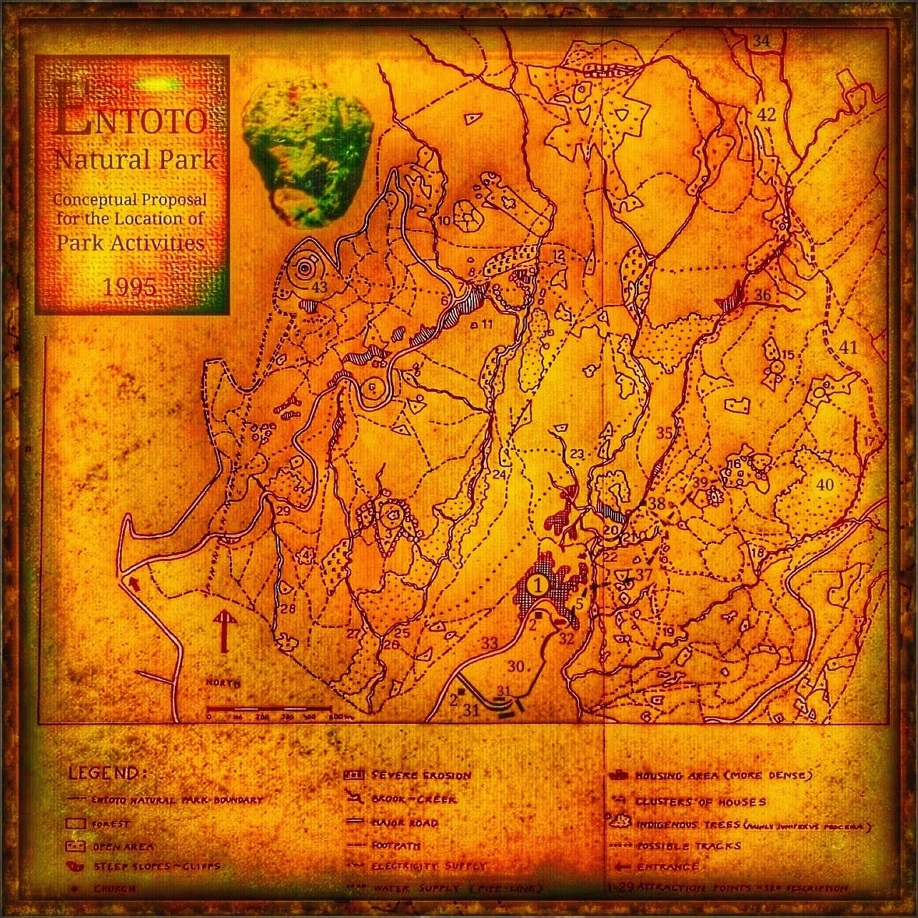
The Extent of Entoto Natural Park's Activities.
The Hidden Treasure at the Mountain's Shoulder.
This place is the work area of many endeavours; Entoto's High plateau appears among adorable Juniper hills and dreamlike meadows. Ultimately, beyond the horizon of golden fields, this landscape of forgotten dreams reveals its southern border in the abyss Bees' Cliff (14). Here it shows very soon; the beautiful path (42) to Entoto Natural Park (Nursery) 34, where the massive work has elapsed with nature restoration for many years.
1. The community Entoto Kidane Mehret.
The community Entoto Kidane Mehret - An Elevated Protectorate.Entoto Kidane Mehret is a very dedicated and appealing mountain town but should indeed more precisely be described as a deeply devoted religious Sanctuary and Protectorate of Nature and Inhabitants.
A trust-making station with the dignity of a cliff fortress.

For a long time, this has been a religious protectorate of Entoto's nature, thus gaining excellent protection that has been deeply associated with religious devotion and conviction. However, the Hotel and Guesthouse is missing, which means that the nearest location to the hotel and guest house for tourism is the Shero Meda (Shiromeda) community.
The most necessary for the Park's experience and picnics and candy shop (2) is across the bus stop from the community (1). For those who are very early in the dawn hours, there is a small shop at the beginning of the Juniper forest, just next to the health spring with its associated buildings (31).
Shero Meda (Shiromeda) - A well-established
Communities for transportation and amenities.
Guest Houses, Hotels and Restaurants.
Shero Meda (Shiromeda) community.This society is the central station for further taxi and bus services to Entoto Kidane Mehret (1). However, the town and station Shero Meda is close enough to Entoto Kidane Mehret to offer a pleasant walk to Entoto Natural Park. Shero Meda (Shiromeda) also allows the easiest access to Entoto Maryam, located on Entoto's plateau.
Accommodation north of Shero Meda (Shiromeda)
The two choices of travel routes starting from Shero Meda centre and continuing up the hill towards Entoto Kidane Mehret and Entoto Maryam offer some small and inviting neighbourhoods here. The outer boundary of Shero Meda is shown a few streets where the roads up to Entoto Kidane Mehret and Entoto Maryam are joined, providing convenient access to amenities up to a mile north of Shero Meda's centre.
Shero Meda (Shiromeda) Centre.
The two travel routes starting from Shero Meda centre and continuing up the hill towards Entoto Kidane Mehret (32) and Entoto Maryam (43), offer some small and inviting neighbourhoods.
Accommodations Towards the Mountain.
3. Damtew's Shola. Once planted by the chief priest of Arada-Giorgis, the former worship place has a strong identity with wide and open lawns laid out as a star. The big Ficus sycomorus tree in the middle makes this place the ideal wedding park. To the southwest, in one of the triangular lawns, the slope naturally forms an area for an outdoor theatre.
4. The Forest of Maryam. Once a year, on October 1 st, people used to go here after the celebration of Maryam and bring food. The woodlot has decreased in size but can be re-established.
5. The Concealed Path of Entoto Kidane Mehret.
A refreshing cool stream still runs in leap and joy, beyond the secrets of Entoto Kidane Mehret's sacred stone walls, (32) a path to Bees' Cliff (14) and further exhilarated explorations.A hidden path between the sanctuary and the gorge.
The trail runs attractively hidden behind Entoto Kidane Mehret (32) in a concealed curve below its wall. This cosily hidden route passes through a small part of the village before the trail's somewhat dramatic ledge (5) opens along a deep ravine and finishing with downhill towards a traditional bridge.The different choices uphill from this bridge starts either from (37) or even (19) is an attractive way to these natural pools just above Bees' Cliff (14).
The paths up to Bees' Cliff (14) offer several options; the northern hillside of the tributary gorge (36), but also the southern slope of (38-39) - (15-16) and (41).
Multiple trail options from the bridge at Kidane Mehret Church (32).
Thus, there are several very different paths choices just uphill from point (38) but also becomes enriched by a more thorough, independent acquaintance with the full south-eastern to north-western eroded soil road (41) located just above points (14 - 16).Grandiose scenarios of the Canyon's trails.
These trails are all characterised by the unique and dramatic slopes at the canyon (35). The options of trails are here beautifully inspiring and often in contact with each other, allowing another choice of a path by a relaxing return or to an intersection towards an alternative height above the gorge. This option might follow the river's shoreline (35) or even at the slope's upper plateau ledge.** However, it is clear that the canyon's slopes in some places are too steep to allow a confrontation with a vertical commitment. Still, this nature drama offers extra interest in wildlife scenarios, thus giving the walks an unforgettable value.
A canyon of adorable beauty and lush greenery.
Independent opinion or perception of these alternative trails, they are all so surprisingly beautiful and varied that they offer far greater entertainment than could be expected from the memories or impressions of the other nature types around the Capital or even compared to the charming countryside with its beautiful scenery. In this magnificent canyon of seductively smooth light and living, shadows are, however, all the paths so captivating inviting that visitors never are at risk without all types of pure and vitalizing surprises.
An invitation of fragrance and cool freshness.
With a pleasant cool freshness, visitors are invited with the flavouring fragrance of mighty native Juniper forests and overwhelming vegetation. Thus, this dramatic landscape assists visitors with thrillingly inspiring canyon routes, effortlessly capturing all the attention that gives both social pleasures, with views and memories of unforgettable beauty.6. Stone Heaps showing the direction of the Entoto Maryam Church. An old way of marking where visitors from afar could spend the night inside the church.
7. Holy Water of Maryam. Originally a spring emerged out of the cliff, but now it is paved. People still drink water to be blessed by the Madonna.
8.,9. Seasonal Waterfalls.
10. Small Hill with Stone Walls. A badly eroded area, due to a moderately steep slope and mature Eucalyptus globulus, but still an interesting place that can be opened and used, either as a herb garden, maze, or to go picnicking.
11. Terraces. It can be opened again for a resting place on the park walk.
12. Stone Piles gathered in 1974 for road construction. Now, they are sculptural elements in the landscape and should be kept as they are.
 |
| Activities and Recreation |
The Routes to the High Plateau
14. Bees' Cliff - A rock dwelling beyond time.
One of the most spectacular spots in the Park, where scenic beauty can be enjoyed while resting. A lot of birds can be seen here.
A Great Wildlife View and Meandering River.
This plateau just above Bees' Cliff is a magnificent place with a great panorama view over the stream and many characters in the landscape. When the scene turns south, the abyss Bees' Cliff (14), the ravine, is very close, where the river's further gorge meandering (35) becomes intuitively felt through the profound cooling airflow rising from the unknown abyss below the field of view.
The ancient place with breathtaking perspective.
With dramatic beauty, this place attracts an exciting approach to exploring an unknown world of nature where environments in this wonderfully excitingly secret dwelling since the beginning of time in the rock formation created scary deep underground gaps and hidden rock chambers* in the midst of their surrounding waterfalls.
A magnificent magic shadow world veiled by time beyond memories.
Here in this enticing deep underworld of shadows and greenery, this treacherous luring cliff vault and abyss gives a home to pure magic twilights where Ravens reside and invite to pleasant arts of flights as well as approaches in playful jacket pinching mischiefs.However, this grande scenario is overall the reason for the attraction of the place. The canyon creates ideal wildlife habitats that naturally utilise this rich, three-dimensional diversity in water and rock formations.
Close Encounter With Playing Baboon Families (14).
While this place is unique in many ways, there are also reservations about the impact people can exert on its nature. Because this site contains what is desirable for people and wildlife, the result is that a conflict of interest and living space can occur.The paths up to Bees' Cliff (14) offer several options; the northern hillside of the tributary gorge (36), the southern slope of (38-39) - (15-16) and (41).
15. Five-mountain-view hill. From the top of the hill, the visitor can overlook great distances. The slope down the hill will be developed into different levels to spread out in alternate attraction choices.
16. Enchanting View Above the Capital
A Great Plateau Ledge for View and Activities.
Arriving at the high viewpoint (16) is very convenient, as the substantial rise upwards offers some beautiful and exciting rests with magnificent scenery and historical surprises with old Italian fortifications (38) and trees of a surprising dignified furrowed patina.The resting place from the era of dreams.
This high viewpoint provides resting places for picnics in social tranquillity and contemplation about the unique nature, which is facilitated quickly by the high point of view, even over the mist-veiled Capital far below the southern slopes. Much closer, the farmhouse is reminded and not far below even the spiritually chanting walls of Entoto Kidane Mehret Church (32).Among breathtaking Views and Juniper Giants' care.
Arriving at this high viewpoint and the outermost plateau ledge is very convenient. The substantial rise offers some beautiful and exciting rests with magnificent scenery and historical surprises with an old Italian fortification (38) and trees of a surprisingly dignified furrowed patina.Deep shadows deliver adventures beyond knowledge.
A little behind the camera's typical view (16) towards the dim-capped Capital is a group of magnificent and powerful Juniperus procera trees. These native and furrowed trees are unique, appear to originate from a past culture, and are near just some steps uphill towards Bees' Cliff (14). For them who want a deeper Juniper forest is a near 50 years old forest of wild and original Juniperus procera trees (40) just close but still hidden behind and in the eastern slope, where they provide a unique insight into how nature emerged before the Eucalyptus trees were introduced from Australia over 100 years ago.
Magic wildlife in the twilight calls for dreams of time.
This native Juniper woodland (40) is massive in its appearance and stunning in vitality, with a perfect, lush and dense undergrowth. The natural health and fertile beauty of this indigenous Juniper forest (40) illuminate with precision the severe nature and habitat destruction that occurred at the introduction of the Eucalyptus tree.17. Hyena Cliff (Jibb Gedel). A waterfall and steep slopes attract an adventurous site, to which a suspension bridge might be added.
18. The Cave. Those who climb up along the brook will find an enclosed space with a small waterfall. This is the spot for those who want to be alone for a while.
19. Italian Water Reservoir.
During the occupation, the Italians established a big reservoir to provide the Capital with water. Nowadays, the reservoir (underground water technology) has lost some of its importance in favour of bigger catchment dams.The Cautious Choice for Families.
Therefore, during the rainy season, it,s, appropriate to enjoy the beautifully undulated promenade to the site of the Italian-built spring water facility (19). Entoto Kidane Mehret's inhabitants are bringing their household water from this source. Therefore the company is apparent by playing children and people fetching quantities of water to their homes.
20. Climbing Cliff. The Italians prepared this very steep cliff wall for climbing. The cliff is impressive in size and can be used again for those interested in this sport.
21. Big Waterfall.
22. Valley Bottom
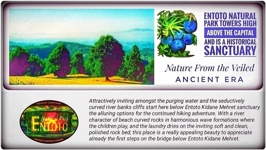
This place is located just at the bridge below the Sanctuary of Entoto Kidane Mehret (32). It is relatively close to the path (5) near Entoto Kidane Mehret Church, with beautiful scenery with a brook passing by. This brook (35) is, in many ways characterizing the views to the dramatic landscape and cliff formations of the uphill trails. The rising hillside of the mountain is provided with an excellent assistant (37) for orientation for the most hiking paths up to Entoto Natural Park (Nursery) 34.A graceful invitation to the waiting adventures
Attractively inviting amongst the purging water and the seductively curved river banks, cliffs start here below Entoto Kidane Mehret (32), the alluring options for the continued hiking adventure. With a river character of beach curved rocks in harmonious wave formations where the children play, and the laundry dries on the inviting soft and clean, polished rock bed, this place is a really appealing beauty to appreciate already the first steps on the bridge below Entoto Kidane Mehret.
Clear and Pleasant Hiking Trails
The southern hillside of Entoto's rising shoulder is here apparent, and from this site (22), with the gully and its valley just beneath Entoto Kidane Mehret (32), the mountain dominating very close. This ancient highland mountain with its secret high plateau of real old serenity lure here intriguingly. The mountain towers in full contact on the opposite side of Entoto Kidane Mehret and its seductive polished rock-gully bottom (22). The mountain's mighty hillside initiates the first steps of Entoto's threshold and rises majestically over the southern slope. In profound veneration of reverence, it appears to any visitors as it towers above relatively high altitude. Caution is, therefore, an essential foundation for preparation because the mountain's rise is quite demanding for visitors with otherwise healthy activities from lowland experience.Towards the Fresh Well-Fragrance of Highland
Despite this somewhat harsh highland air, the hiking is captivating and comfortable but requires regular rest and is essential to drink regularly. This is from the brought-with and robust water bottle. However, underneath in the valley and just after the handcrafted bridge rises the mountain's slope towards Entoto's high plateau continuously upwards towards secret places of pure serenity, often with views of breathtakingly beautiful sights. The Paths rise towards breathtakingly sublime heights of aesthetically unforgettable dream paths. Well fragrant and aesthetically unforgettably alluring are these paths from Entoto Kidane Mehret's valley bottom (gully 22) and the river (35).
The Rising Shoulder of Entoto's Massif
Here the trails follow a clear direction up to Entoto's high plateau. Furthermore, all of these paths includes exciting and surprisingly attractive paths along the eastern slope of the river bank; they are straightforward to follow in the landscape. This visible clarity in the appearance and selection of trails is apparent here, thanks to the attractive overview of the sculptural introduction towards this very family-friendly gorge.
A Guiding Canyon Deliver Path Assistance
The open and pleasant contact with the lush hillside of these riverbanks towards the river (35) and its mysterious twilight cleft is here apparent and an excellent place for the well-equipped family to appreciate unforgettably thrilling adventures but also the most pleasant magical mountain views where cosy picnics places offer an utterly captivating nature.
24. Shewarkaw's House. Here, a chief Guard once had his house built with covering leather. Now the area is open, and people pass through on their walk downhill.
25. Abbah's Waterfall. The park area is generously provided with waterfalls, but this is one of the most spectacular.
26. Hermit's Cave. Not long ago, a hermit had his home in a narrow opening in the cliff, and only he knew how to get there.
27. Seasonal Waterfall.
28. Shintobele's Spring. This brook was named after the father of a well-known man on Entoto, Ato Fitawari Ayenew. It is used as a seasonal water supply for the neighbourhood. By conserving watersheds in the Entoto Natural Park, the water quality will be improved.
29. Ato Bekele's Juniper forest. A stand of beautiful, mature junipers is still remaining here, thanks to the care of Ato Bekele. Some fully grown Cypressus lucitanica, planted 30 years ago, can be seen, too (Håkan Blanck and Pia Englund, Entoto Natural Park 1995).
The Hidden Treasure at the Mountain's Shoulder ( 1 )
(30 -31 -32- 33) Entoto Kidane Mehret Church, Community,
Monastery, Sacred water source, Juniperus procera Forest (indigenous).
- Quite close to this weathered map's central parts but fairly far down, it can clearly be seen where Entoto Kidane Mehret Church (32) can be discovered where it is located on a small northern bend of the completed road.
- Although Entoto Kidane Mehret is quite highly located and appears distant due to its height above the Capital, it's equipped with a station for regular bus and taxi traffic.
- Completely surrounded by its society, this station is characterized by an inviting cosiness, but together with an accompanied impression of magnificence that cannot be expected in a massive rock ledge of a mountain.
- This station would be disproportionally abundant if not for the sanctuary that discreetly dominates its outer propagation. The station of Entoto Kidane Mehret [1] is it is located beautifully on this dramatically elevated hidden mountain plateau where it appears like an essential marketplace so generously dominant right next to this quaint community (1).
- This unique town's structure creates here a harmonic embrace of the extensive and impressive Entoto Kidane Mehret Church (32), Monastery and Sacred Water Source (31), Juniperus procera Forest (indigenous) 30.
- In addition, this sanctuary with its Church and Monastery are astonishing hidden, tucked into the mountain massif rising shoulder where perception arises very soon to be careful because precipices and gullies take over immediately when you just move away from a little piece of this remarkable protective plateau and its quaint surrounding mountain ledge town (1).
The Ascent to the Community Entoto Kidane Mehret.
Along the anticipated and continued fairly steep climb of the road is the experience of native forest (30) within arm's length of a charming but surprising contact. Just very close, on the right side of the road, this native forest towers in a revelation and guise of a completely fenced but mighty Juniper forest (30). This original Juniper forest spreads out vigorously from the steep ascent beginning (31) and up to the road's clearance, completely beside Entoto Kidane Mehret (32).The Source at the Mountain's Shoulder.
At the first part of this protected and protective forest, you find yourself a good piece below society but are nonetheless part of its togetherness. The forest here (30) is impressive and serves the essential purpose of maintaining clean and uncontaminated spring water.Juniper Mountain Spring.
Just to the right and slightly below (31), at the beginning of this step, well-fenced juniper forest is a highly sought after and famous building where the water from this mysterious, ancient place will arrive in cascades and qualitative amounts.Enchanting and Reigning Juniper Mammoth Trees.
Here, immediately behind the muscular columnar Juniperus procera trunks and many layers of wire prohibition protection arrives this spring water (31) with gurgling sounds. Very mighty this forest dominates its environment and imparts a refreshing crystal clear source below the gnarled roots of these stately venerable and furrowed columns of guards in the shape of ancient patinated Junipers.Facilities and Amenities at Entoto Kidane Mehret.
This community is equipped with shops (2) for the most important, culturally beautiful buildings with associated spring water and the indigenous forest of giant Junipers (30). These constitute significant assets altogether for all types of adventures, picnics, and hiking in the varied mountainous terrain of Entoto Natural Park.The community Entoto Kidane Mehret.
The society Entoto Kidane Mehret (1) is a very dedicated and appealing mountain town. Still, this charming settlement should be described more precisely as an impressively extended but quaint mountain town at a mighty and deeply religious Sanctuary and Protectorate of Nature and Inhabitants.34. Entoto Natural Park (Nursery)
This place is the work area of many endeavours; Entoto's High plateau appears among adorable Juniper hills and dreamlike meadows. Ultimately, beyond the horizon of golden fields, this landscape of forgotten dreams reveals its southern border in the abyss Bees' Cliff (14). Here it shows very soon; the beautiful path ( 42) to Entoto Natural Park (Nursery) 34, where the massive work has elapsed with nature restoration for many years.The picturesque path among adorable Juniper hills.
This excursion to the Nursery is a pleasant wandering with a minimum change in altitude, where it usually permits dry rock to wade over to the west side of the meandering stream (35). By this direction, the trail passes just a little besides the natural pools above Bees' Cliff (14). Then within short a path (42) in a romantically inviting landscape of meadows and smoothly rounded Juniper hills with indigenous and juvenile forest, before arriving at the Nursery (34).During these years of extensive nature conservation activities, this building has been very significant, and the work had not have been possible without its existence.
https://www.flickr.com/photos/unicefethiopia/13733831655
35. The Stream with Canyon and Waterfalls.
The stream of these hiking adventures starts just below Entoto Kidane Mehret with a character of beach curved rocks in harmonious wave formations where children play, and the laundry dries on the inviting soft and clean, polished rock bed.Caution During the Rainy Season.
However, provided that the trekking not is made during rainy periods, the long stretches of tributary river banks (35) also offer a lot of relaxation and enjoyment, especially after that the path deviates and continues upward just before the old pipeline joins the reservoir of the Italian fortification (38).** 35. Very Clear Restrictions for further hiking
Attention, the safety boundary of the continuous path along the river's shoreline (35) clearly indicates that this route does not include the gorge with further upwards abyss hiking after passing the tributary creek (36). In addition to being a lovely and cosy inviting place, this tributary (36) represents the last comfortable direction and route up towards Bees' Cliff and thus Entoto's high plateau. Although Bees' Cliff (14) is very near here, towering dramatically above its vertical cliffside is directly dangerous except for possible experts with safety harnesses and other equipment.
A leisurely return to the trails of the southern slopes.
Visible and Pleasant Hiking Trails.
Season Limited Creek Hiking
This dry creek bed hiking can be an exhilarating experience in this concealed cliff space where shadows sweep deeply in soft greenery shifts. This compactly deep, alluring cliff space is indeed temptingly exciting and enticing. The dark underground passages in shadows are just waiting for actions in a somewhat overwhelming flow of impressions.**Observe, the hiking directly in the dry brook bed is only possible if it has elapsed some months since the last rainy season but then offers adventure experiences that are unique to those who may have the courage to surprise a pleasant strenuous Hyena.
Harmonic Currents Along the River.
Since all streams around Entoto run-up within a short distance to the highest part of the plateau, there is no risk of being surprised by far and accumulated sudden river flow from an unknown range. There is no known weakness in the deep rock pools that could constitute a magazine water mass just waiting to break through a weak point in the cliff bottom.** However, be careful and expect even the worse type of scenario because the animals are wild. Even the most reliable rock will break if the lousy luck together with a very rare and significant earthquake would be coincident.
36. A Multiple, Spatial Nature Dream.
These two streams meet, a place of idle creative nature is created, splendid surprises in both hidden prongs and open spaces with mighty slopes. The one who stays a little concealed between the tree trunks at point (36) can quickly get very close to rumbling and relaxed hyenas. The southern slopes of the creek (36) are pretty steep yet comfortable hiking with beautiful views down over the mysterious river but still inviting open gorge to the river (35).Excellent fun canyon hike towards the high plateau.
The hillside above the tributary creek (36) is the last choice of a hike from the canyon (35) to reach the high plateau (41) - (42). The path is somewhat steep but offers a relatively gentle than a wild hike towards Bees' Cliff (14), and its direction uphill is along the northern hillside of the tributary gorge (36). Initially, the path above the tributary creek (36) is quite rugged, but as the plateau's threshold is very close, the walk upwards becomes less burdensome.
A walk in the abyss with the secretive company of hyenas.
Directly from the route's start in this small hidden gorge (36), gentle winds deliver pleasure with a fresh coolness in a welcoming breeze from the canyon below that is well camouflaging the scary smells of civilization from reaching the hyenas in the depth of the gorge (35).A pleasant easternized route along the tributary gorge 36.
However, the abyss is here close and with due care; therefore, a more easternized commitment of the route should be preferred and not only for increased safety but also in purpose to avoid suddenly scaring wildlife that enjoys socializing around the scenic pools right above the plateau threshold and the abyss of Bees' Cliff (14).37. A Very Clear Guiding to the High Plateau.
The path uphill along the pipeline is beautiful and demanding.
A guiding pipeline just above the traditional farmhouses (37).
 |
| Bees' Cliff 14 require caution in the canyon but assists by the wide map loop surrounding the gentle and fascinating points 36 and 41-42 |
The Assistance of Path Directions (37)
The superficially lying water pipeline (37) from below makes the path easy to follow and reaches a high level on the mountain's shoulder. Just before the Italian fortification (38) appears a theatrical view and potential dangerous abyss* a few metres to the left of the path. The location of this precipitous* view is within the lower sections of map circle (B). The route deviates in two different choices when the pipeline makes its high northern bend just to the right of (38) - (B), where the uphill steeper path gives the direction to the most hiking routes.The highest crested curve of the pipeline provides a choice of paths.
Just before the Italian fortification (38) - (B), the path deviates in two different choices when the pipeline makes its high northern bend. The path along the pipeline goes with a final horizontal direction towards its connection to the Italian fortification (38) - (B) with its reservoir and steep waterfall. Thus, within the map circle (B) and a few right steps upwards of some metres, it reaches up to an invitingly gentle rising threshold in the shape of an eroded and natural hill shelf. The actual way upwards departs before any visible contact with the Italian fortifications, leaving the pipeline's direction just at its highest crest in a perpendicular direction towards the point (39) - (B).38. The Italian Fortification and its Bath.
This Italian fortification (38) - (B) (historical remain) is very close to the actual path upwards, and just above is the location of the farmhouse (39) - (B). Just here, little downhill, the pipeline's farmhouse area connects to the reservoir and underground installation from Mussolini's troops. It is an interesting and short deviation from the path to visit this place and also beautiful.** A Thorough Bath Examination is Required in the Italian fortification.
While this is an old Italian fortification (38) - (B), all kinds of bath demand must first be preceded by a thorough bottom and wall examination to ensure the safety conditions of the reservoir where both larger stones and iron objects could pose a severe injury hazard.A green path along the riverbank within the charmingly inviting gorge.
The trail that deviates just before the Italian fortification (38) - (B) becomes after a while very inviting when approaching the slopes to the riverbank (35) and provides an extensive spatial full contact from within the gorge, including both the river and the riverbank's green and rising wild uphill slopes.39. Wild Meadows with Farmhouse.
Above is the farmhouse (39) - (B) with large Juniperus procera trees along its upper hillside. Furthermore, upwards the path turns slightly to the right towards the location (16), just at the high plateau's outer edge and even here with many incredible stately Juniper trees. Some original, indigenous Podocarpus trees, found from a much previous era, appear admirably muscular furrowed around the extensive farmhouse (39) area just below point (16), which are a great pleasure for any other soul with a passion for nature.40. The Wild and Fertile Forest from the Ancient Era.
This is just over 50 years old, indigenous Juniperus procera forest that provides a unique insight into how nature emerged before the Eucalyptus trees were introduced from Australia over 100 years ago. This native Juniper woodland (40) is massive in its appearance and stunning in vitality, with a perfect, lush and dense undergrowth. The natural health and fertile beauty in this indigenous Juniper forest (40) illuminates with precision the healing capacity of a native forest and the severe nature and habitat destruction that occurred at the introduction of the Eucalyptus tree.41. A Wide Trail from South-East to North-West.
Although, this ground road (41) towards Bees' Cliff pools is eroded and requires some maintenance before use by cautious, conventional tourists vehicles. However, its extent is suitable for reaching these nature pools at Bees' Cliff (14). It is, therefore, an open and beautiful way for a promenade to the rock ponds (14) or further brook ford wade to Entoto Natural Park (Nursery) 34.42. The Path Towards Entoto Natural Park (Nursery).
The landscape to the north is very moderate and reveals very soon; the beautiful path (42) to Entoto Natural Park (Nursery) 34, where a massive work has elapsed with nature restoration for many years.The high plateau, its brook, wade and ford crossing (41-42)
This is the beginning of the high plateau where invitingly gentle cliff formations offer this picturesque wade across the stream (35), thus giving the entrance to the path (42) towards Entoto Natural Park (Nursery). This brook represents just here the separation between the eroded road (41) and the continuing trail (42) towards Entoto Natural Park (Nursery). The waterfall at Bees' Cliff (14) and its sheltered vaults are recalled here very close. When gazing further along the canyon to the south, it delivers a dreamlike reminiscent fragrant hint of this nature's serenity while it far below the curtains of the morning's mysterious veils reveals Entoto Kidane Mehret and the Capital.A. The Character of Entoto Kidane Mehret's valley
B. The Invitation to the crossroad of wilderness
The square (A) serves as a directed and facilitating figure to more easily find points (5), (22), and (37) which are located and form the valley at Entoto Kidane Mehret (32). This area (A) is the beginning of most of the following hiking trails described.

Direction Map to the Alluring Past.
The square (A) serves as a directed and facilitating figure to more easily find points (5), (22), and (37) which are located and form the valley at Entoto Kidane Mehret (32). This area (A) is the beginning of most of the following hiking trails described.
The square (A) serves as a directed and facilitating figure to more easily find points (5), (22), and (37) which are located and form the valley at Entoto Kidane Mehret (32). This area (A) is the beginning of most of the following hiking trails described.
The Gentle Crossroad to Wilderness (B).
The area shown within the circle (B) includes the points (35), (38), (39) and constitutes both a crossroads of somewhat wild paths but also a beautiful floor rise at a threshold that begins within the lower regions of the circle. This crossroads is located just to the right of point (38), but regardless of the hiking paths within the loop point (B), all of these will soon contact the continued walk towards the higher positions.
With this excursion towards the Nursery, the impression of the high plateau is evident and a clear contrast to the quite steep hiking up from the sculptural river banks at Kidane Mehret. Behind now is Bees' Cliff's adventurous and beautiful experience (14) and the adorable viewpoint (16). But still, they are very near, with Bees' Cliff just some ten metres to the south and the adorable viewpoint (16), now behind but yet in close walking contact located on the threshold below the southern edge of this high plateau.
A path among adorable Junipers and golden meadows.
The remaining path to Entoto Natural Park (Nursery) 34 is a pleasant wandering with a minimum change in altitude. Except for the rainy season, the brook usually permits dry rock to wade over to the west side of the meandering stream. This direction passes just a little besides the natural pools above Bees' Cliff (14) and then further north through an open forest before arriving at the Nursery (34).A Turmoil of Chaos in Waterfall and Thunder.
However, the plateau location is above any instant protection by the community's taxis, bus station and shops from the quaint ledge town (1) and Entoto Kidane Mehret Church (32). Due to this harsh reality, some reservations are required for the season time when this high plateau is appropriate for visits and when the site needs extra caution.Observe, One Heavy Rain Season Every Year.
There are two rainy seasons per year, the small rain season from March to May and the big rains from July to September. The highest rainfall intensity occurs in July and August (Demissew 1988). This place may appear scary during the relatively long rainy season. Thus, during the rainy season, the water flows are high and intertwined with rapidly unexpected thunderstorms where only a powerful terrain vehicle would protect.Some Mornings Hours of Wonderful Respite.
While this site offers an exhilarating beauty and the fact that the tempests usually follow a bound rhythm, its experience in beautiful, cosy daily hours can be both an exciting and irresistible occurrence, providing a conscious behaviour to return in time before the next thunderstorm.43. Maryam Church, Museum, Palace.
" From the late 1870s, Menelik began to show an increasing interest in the region in which Addis Ababa is situated and headquartered the royal camp at several sites in the area.His first major settlement was established on the slopes on Mount Wuchacha, west of the present settlement. Still, he soon moved northwards and set up his camp near the summit of Entoto Mountain, a choice determined by strategic considerations. Here he erected a palace''...
''The next important building to be constructed at Entoto was the church of Maryam, a circular structure, the foundations which were laid in 1885.
Menelik, it is said himself participated in the buildings' work. On occasion, he travelled with his consort, Queen Taytu, to Mount Managacha to the west, where he helped to prepare massive squared roof beams carried dozens of kilometres by groups of four or five soldiers.
Menelik was crowned Emperor of Ethiopia at this church of Maryam in November 1889, and an effigy of the old monarch can still be seen on its walls. ''(Hancoch et al. 1983, pg102.)
But the establishment of the Capital on the slopes of Mount Entoto did not turn out well: ''Entoto, as Menelik's Capital, rapidly acquired a considerable population.
At the beginning of the century, the British game-hunter and ethnographer, P.H.G. Powel-Cotton, described it as ''a populous city''. At the same time, his compatriot, Herbert Vivian, believed that it ''must have comprised 50 000 souls.
''The site, which had initially been selected as a fortress, was not suitable as a Capital for more peaceful times. Being situated on a rugged mountain, it was poorly supplied with provisions that could only be brought after an exhausting walk.
Food, as Ilg reports, was often scarce, and wood and water were also difficult to obtain. Entoto's climate during the rainy season was moreover far from pleasant, for it suffered from many storms.
A French traveller, Jules Borelli, states that it was a place of much lightning, thunder and fog, while his compatriot, Charles Michelli remarked that, ''exposed to the wind, difficult of access, and without drinking water'', the town was ''an impossible capital''.'' (Ibid, pg 103)

Z. Entoto Park (Inquiries)

The New Facilities of Entoto Park (Z).
The facilities of Entoto Park (Z) are located just below the Entoto Maryam (43). These newly built facilities should inform the regulations for special open hours of this very modern and extended centre for Entertainment, Culture, Art, Sport Activities and Breathtaking Highlands View of Nature and Mountain. However, the freshly made Entoto Park is in its first phase of organizational development and is challenging to give personal service time. Despite this, there are probably conditions for direct contact with restaurants at this newly inaugurated Entoto Park (Z).
Entoto Natural Park (Nursery)
Google Maps:
Z. Entoto Park
Horseback riding service
Website:
Google Maps:
Entoto Park (Inquiries):
Google Maps with Entoto Natural Park road and map info.

Comments
Post a Comment